

Suitability analysis of remote sensing monitoring methods for grassland vegetation growth
-
摘要: 草原植被长势遥感监测具有时效性高、覆盖范围广的特点, 及时高效的草原长势遥感监测信息对于草地资源的保护与合理利用具有重要意义。为明确不同作物长势遥感监测方法在草原长势信息监测中的差异及其应用的局限性, 本研究利用MODIS数据的NDVI产品, 将直接监测法、植被生长过程曲线法、同期对比法、基于NDVI百分位数法分别在内蒙古自治区西乌珠穆沁旗草原进行了应用和适宜性研究, 并对其长势遥感监测结果进行了验证。结果表明, 直接监测法利用草原NDVI数值直观地反映了草原植被长势的空间异质性, NDVI数值与草原单位面积产草量干重显著相关(R2=0.5502), 但对不同类型草原内部的长势差异信息反映不够清晰; 植被生长过程曲线法集总地反映了监测区域草原整体长势随时间的变化, 以及相对于参考年份的差异, 但不同草原类型需要单独监测才能反映其各自的生长过程, 本研究中草甸草原和典型草原NDVI过程曲线的峰值分别为0.73和0.55, 与全区域集总式监测结果(峰值为0.60)差异较大; 同期对比法因参考年份的不同产生不同的评价结果; 基于NDVI的百分位法能够定量地评价草原的长势, 长势评分与草原单位面积产草量干重相关性的决定系数为0.5047。实际监测中应依据草原监测目标选择适宜的方法或组合。随着天-空-地一体草情长势监测平台的建设和发展, 将能提供实时的地面监测辅助信息, 有效提高草原植被长势遥感监测的效率与精度。Abstract: The research and application of grassland vegetation growth monitoring methods have important scientific significance and application value for the sustainable use of grassland resources and the improvement of the ecological environment. Remote sensing monitoring has characteristics such as high timeliness and wide coverage, and several remote sensing monitoring methods have been increasingly used in crop growth monitoring. As the monitoring objects are all plants, these monitoring methods were tried to introduce to monitor grassland vegetation growth in this study. We applied four remote sensing monitoring methods for the crop growth: direct monitoring, vegetation growth process curve, same period comparison, and NDVI percentiles to the grassland vegetation growth monitoring of West Ujimqin County in Inner Mongolia; to clarify the suitability and limitation of these remote sensing monitoring methods for crop growth when monitoring grassland vegetation growth using MODIS Vegetation Index Products (NDVI). The monitoring results provided by the direct monitoring method and the NDVI percentile method were compared with the ground sampling data. The direct monitoring method could intuitively reflect the spatial heterogeneity of grassland vegetation growth by the grassland NDVI, and the NDVI value was significantly correlated with the dry weight of grassland yield per unit area (R2=0.5502). However, this method could not provide details on the growth of different types of grasslands owing to the limitation of the NDVI grade. The vegetation growth process curve method could only collectively reflect the changes in the overall growth of the grassland in the monitored area over time, showing that the growth was better or worse than that of the reference year. In this study, the NDVI peak values of the vegetation growth process curves for the meadow grassland and typical grassland were 0.73 and 0.55, respectively, significantly different from the whole regional lumped monitoring results (NDVI peak value was 0.60). This means that different grassland types should be monitored separately to reflect their respective growth processes. For the same period comparison method, if the selected reference year was different, the method would provide different monitoring results for grassland growth; the results from grassland growth monitoring were semi-quantitative comparative. Using the statistical analysis of NDVI data of different grassland types for 5 years, the NDVI percentile method could quantitatively evaluate the growth of corresponding grassland types, as shown in this study. The determination coefficient of the correlation between the growth score provided by the NDVI percentile method and the dry weight of grassland yield per unit area was 0.5047. To achieve a reasonable classification of these semi-quantitative monitoring results of grassland growth, the assistance of ground grassland monitoring information is required. There is an urgent need to establish a sky-air-ground integrated grassland growth monitoring platform to improve the efficiency and accuracy of grassland vegetation growth monitoring.
-
Key words:
- Grassland vegetation /
- Growth /
- Remote sensing /
- NDVI /
- MODIS data
-

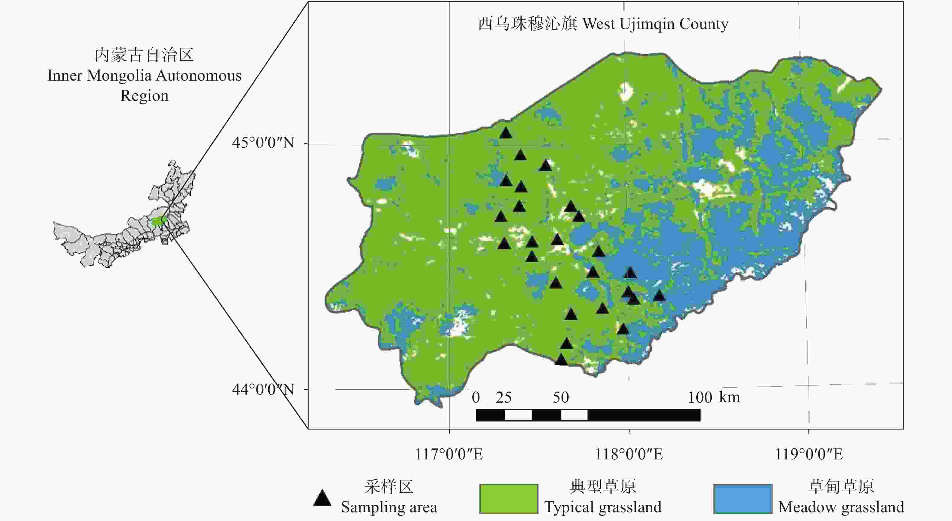
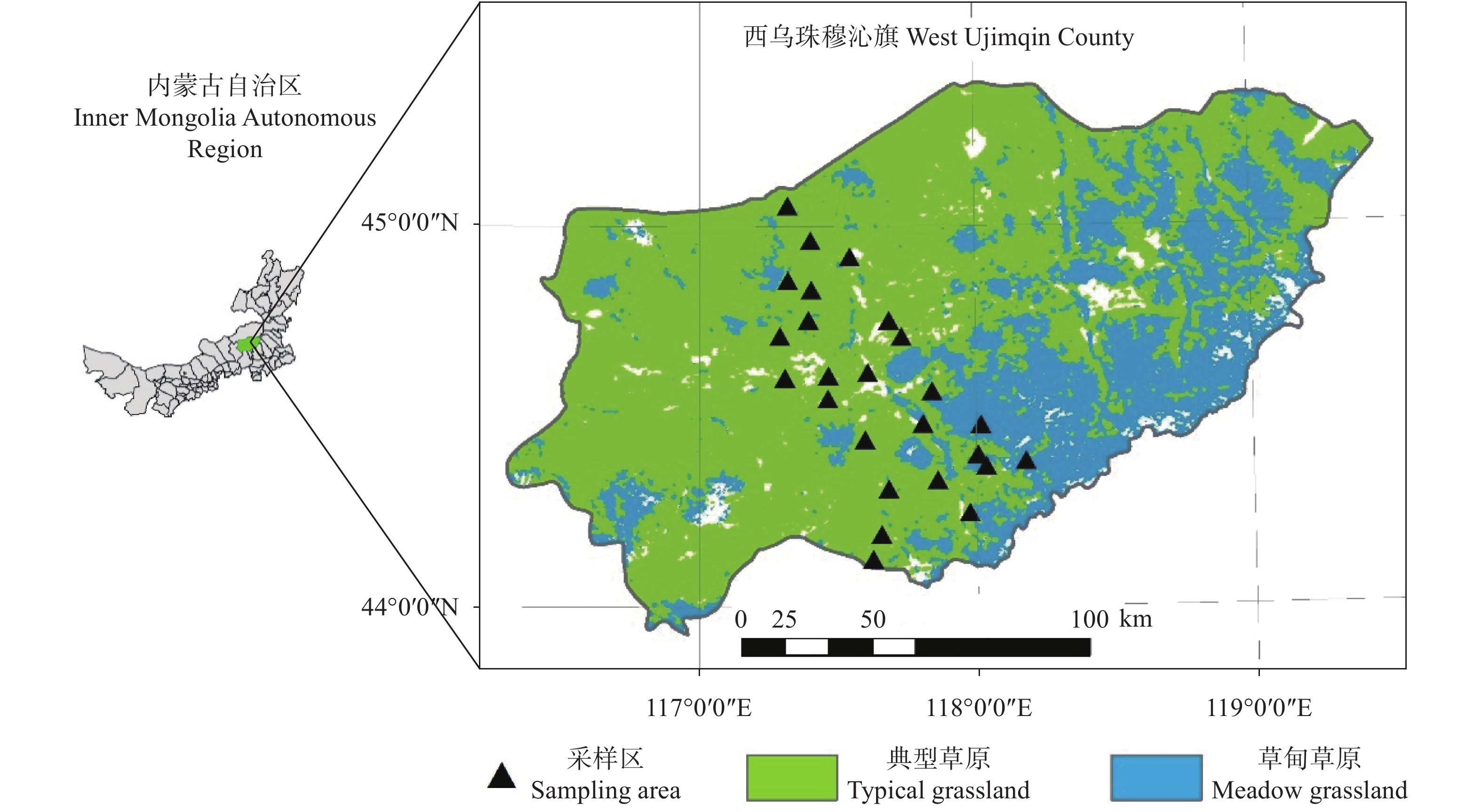
图 1 西乌旗草原类型及采样区分布
Figure 1. Distribution of grassland types and sampling areas of the study area
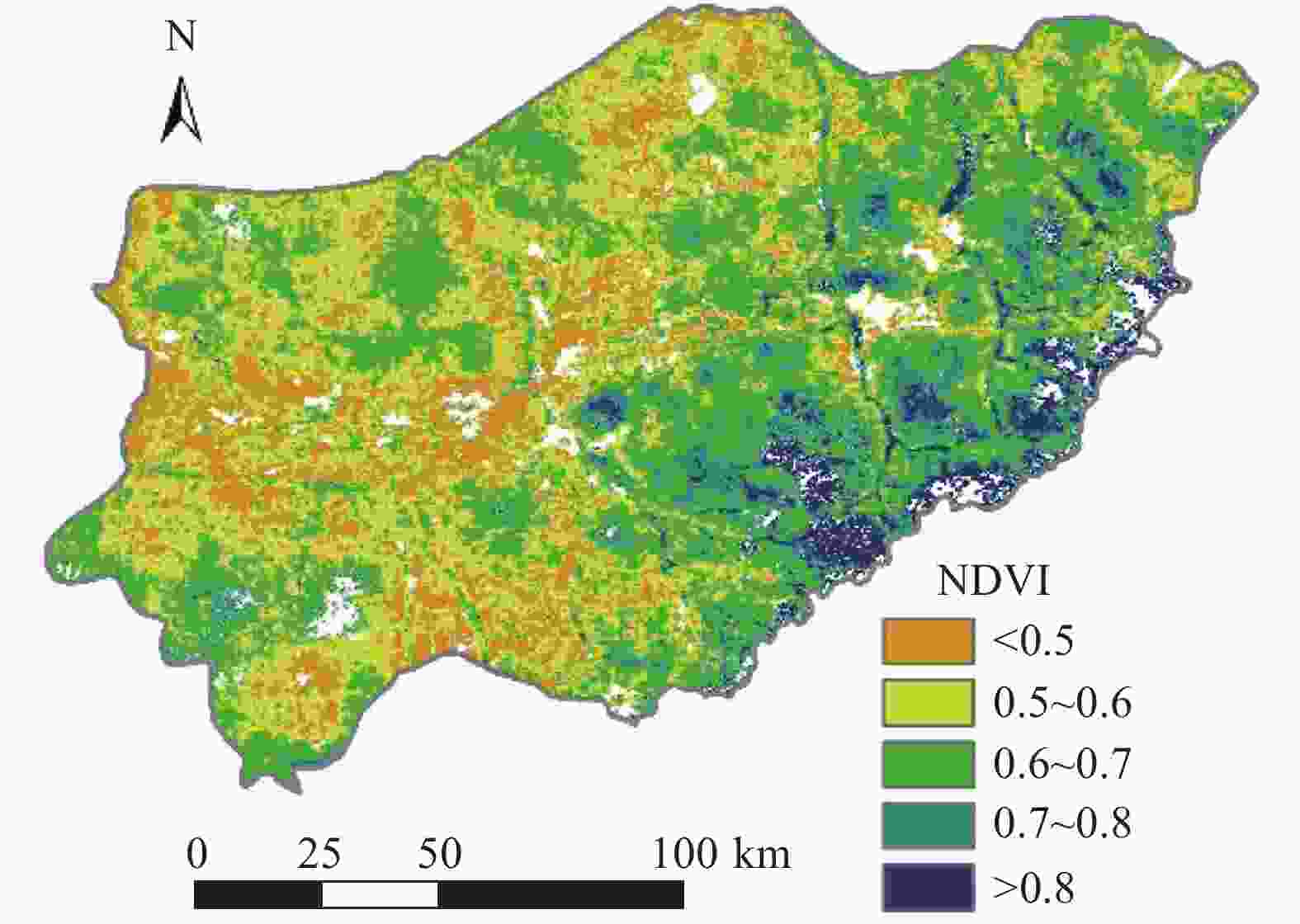
图 2 基于NDVI数值的西乌旗草原长势等级划分(2020年7月26日)
Figure 2. Division of grassland growth based on NDVI for the study area (July 26, 2020)
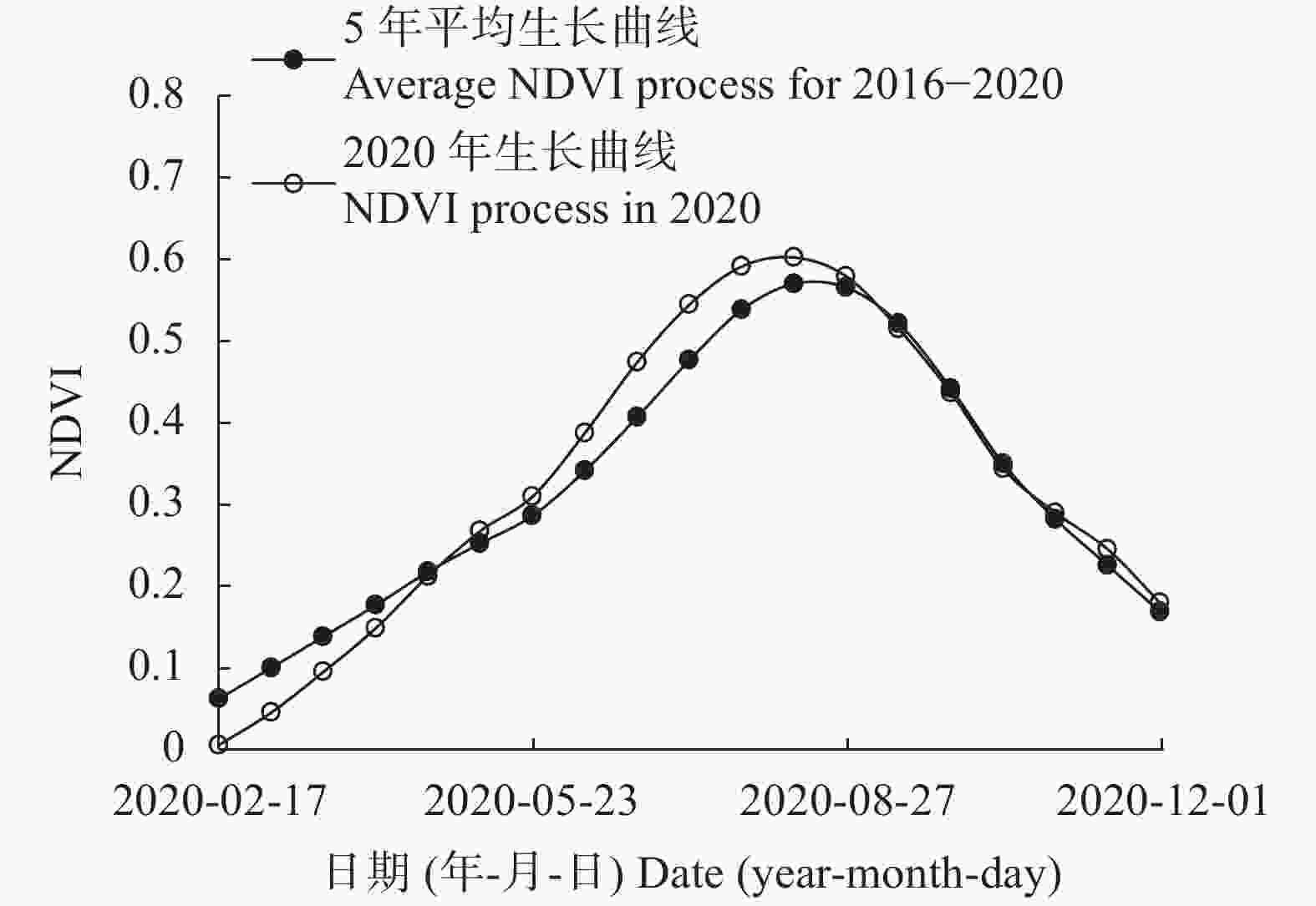
图 3 2020年草原植被生长过程曲线与近5年(2016—2020年)平均生长过程曲线比较
Figure 3. Comparison of grassland vegetation growth process in 2020 and the average one for 2016−2020
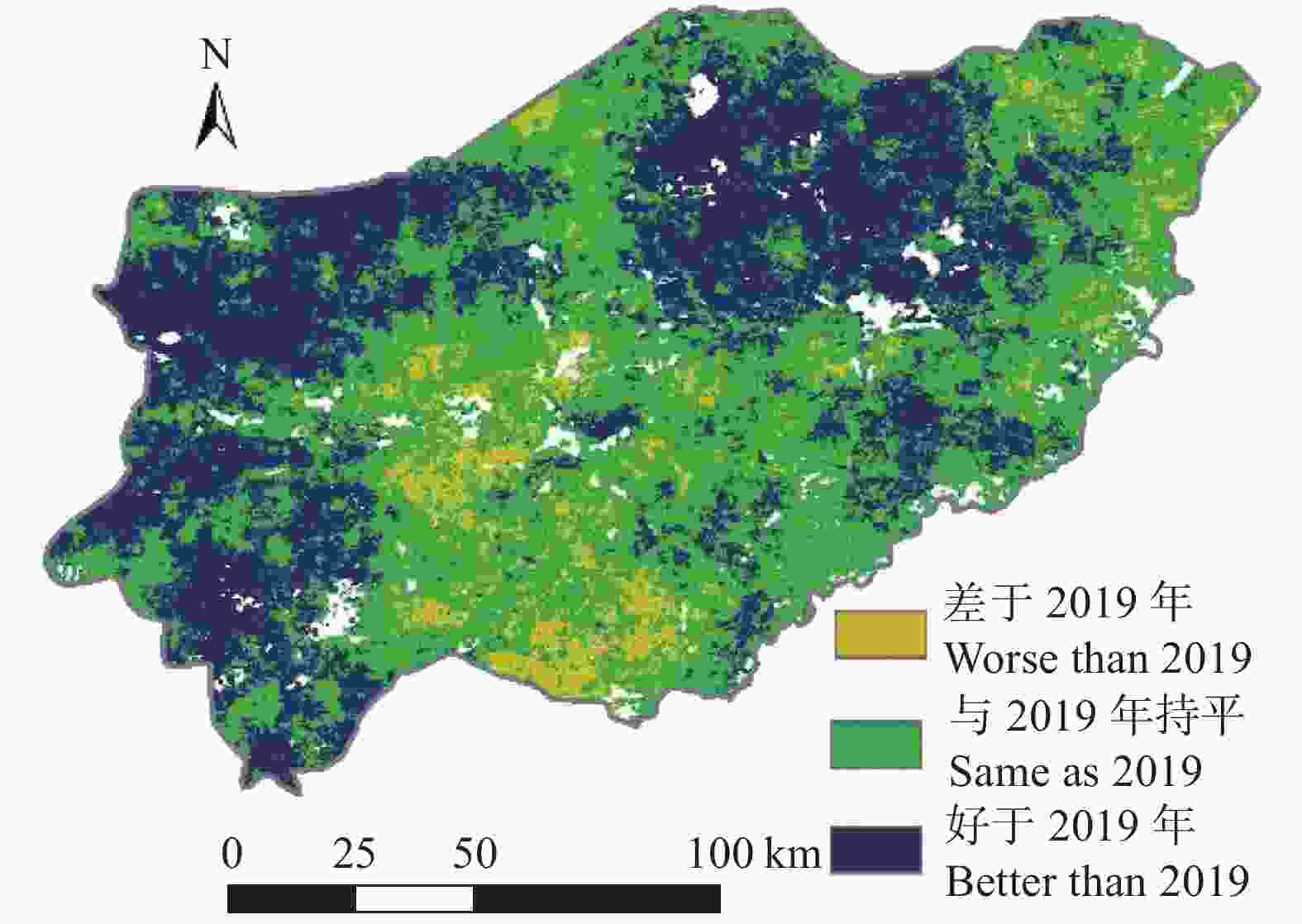
图 4 2020年与2019年7月同期草原植被长势比较
Figure 4. Comparison of grassland vegetation growth in July of 2020 and 2019
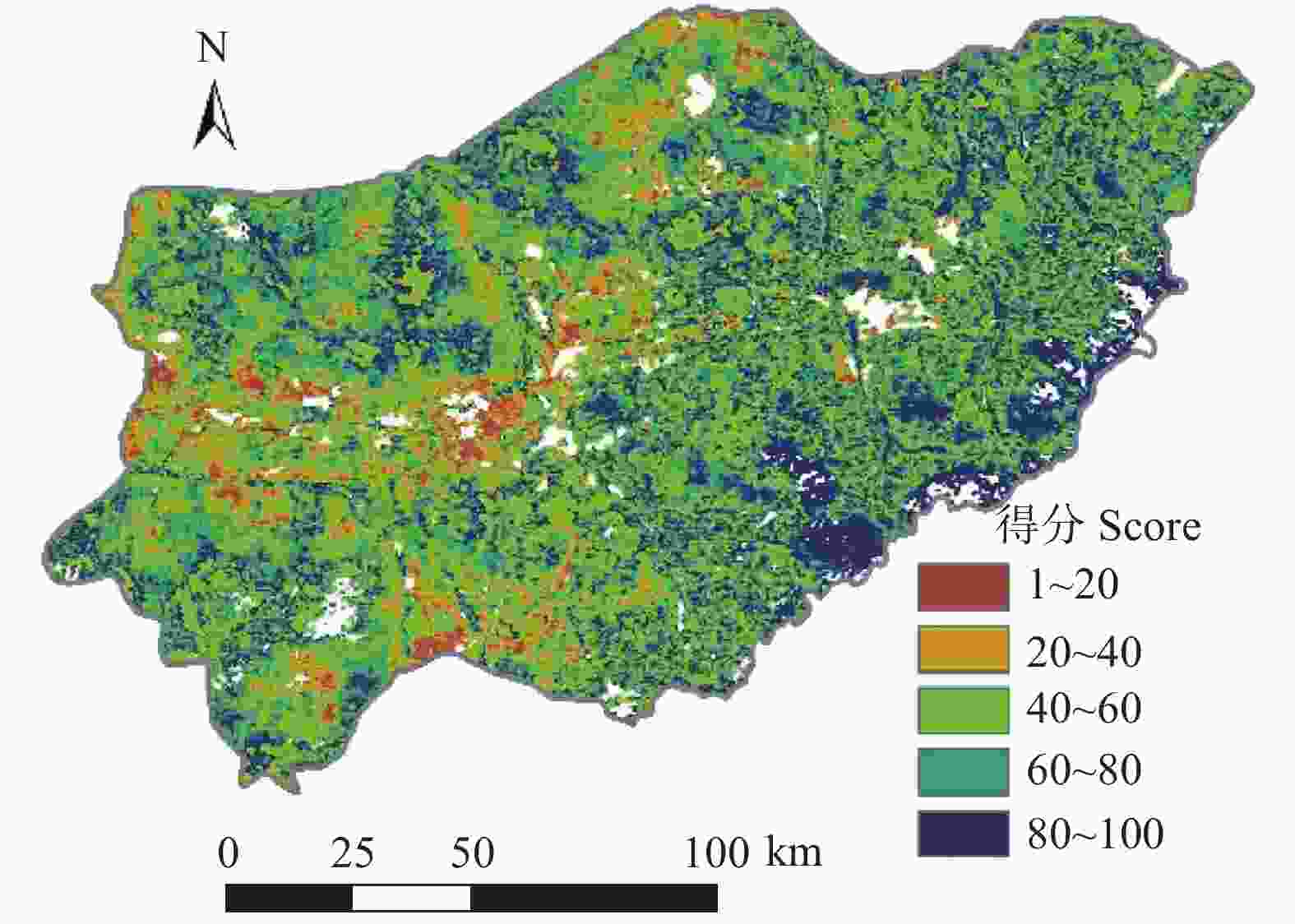
图 5 基于NDVI百分位数法的草原植被长势评分
Figure 5. Evaluation of grassland vegetation growth based on NDVI percentile method
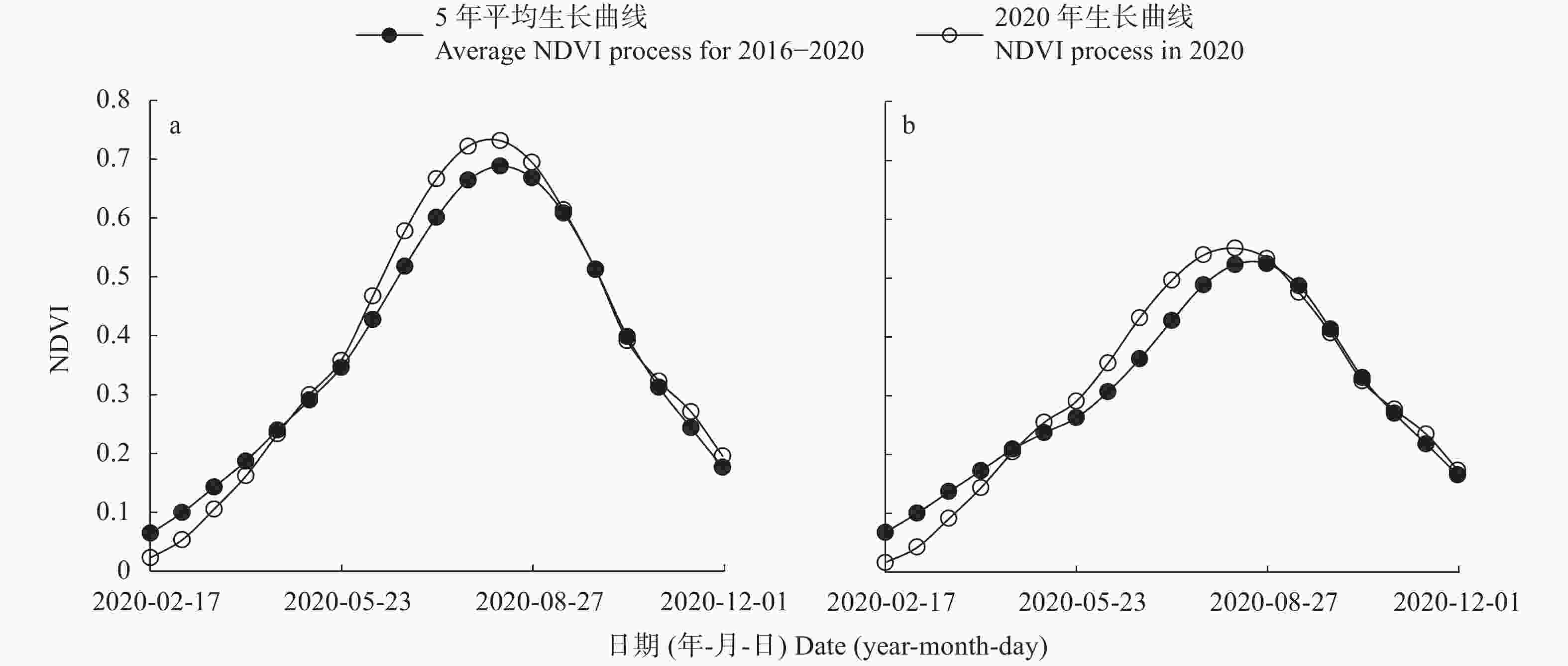
图 6 2020年草甸草原(a)与典型草原(b)植被生长过程曲线与近5年(2016—2020年)平均生长曲线比较
Figure 6. Comparison of vegetation growth process for meadow grassland (a) and typical grassland (b) in 2020 and the average one for 2016−2020
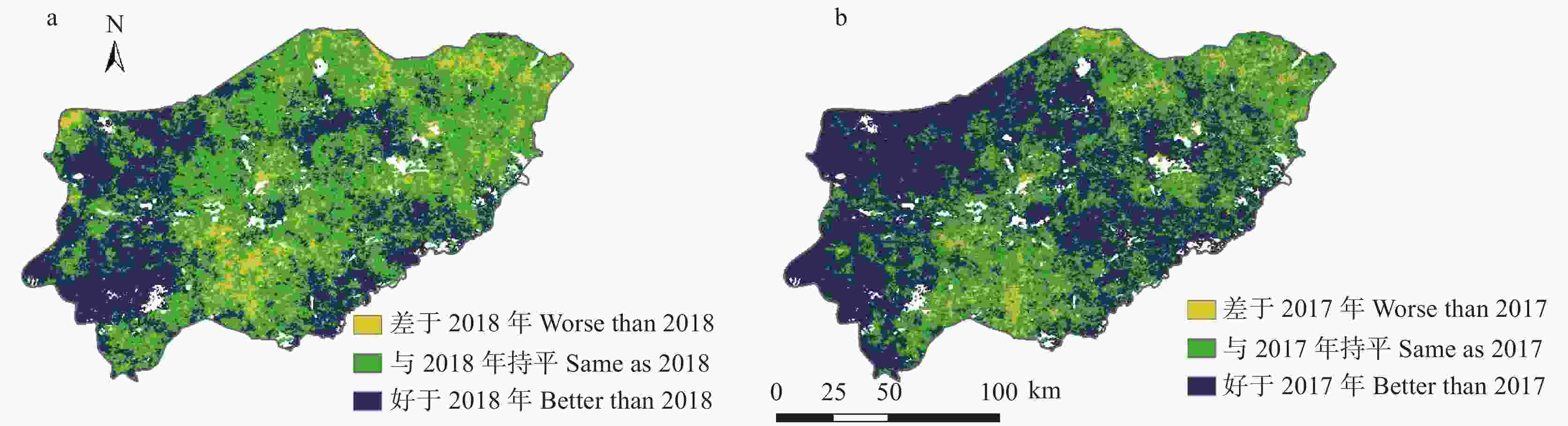
图 7 2020年与2018年(a)和2017年(b) 7月同期草原植被长势比较
Figure 7. Comparison of grassland vegetation growth in July of 2020 with 2018 (a) and 2017 (b)
-
[1] YANG X C, XU B, ZHU X H, et al. A monitoring indicator system for remote sensing of grassland vegetation growth and suitability evaluation—a case study of the Xilingol Grassland in Inner Mongolia, China[J]. International Journal of Remote Sensing, 2015, 36(19/20): 5105−5122 [2] 于海达, 杨秀春, 徐斌, 等. 草原植被长势遥感监测研究进展[J]. 地理科学进展, 2012, 31(7): 885−894 doi: 10.11820/dlkxjz.2012.07.007YU H D, YANG X C, XU B, et al. The progress of remote sensing monitoring for grassland vegetation growth[J]. Progress in Geography, 2012, 31(7): 885−894 doi: 10.11820/dlkxjz.2012.07.007 [3] 高睿. 多尺度遥感方法对牧草营养成分的反演研究[D]. 哈尔滨: 东北农业大学, 2019GAO R. Research on retrieval of pastures nutritional ingredients based on multi-scale remote sensing methods[D]. Harbin: Northeast Agricultural University, 2019 [4] 段淳清. 内蒙古草地资源现状及其可持续利用对策[J]. 内蒙古草业, 2006, 18(3): 21−25DUAN C Q. The present situation and sustainable utilization countermeasures of grassland resources in Inner Mongolia[J]. Inner Mongolia Prataculture, 2006, 18(3): 21−25 [5] 田海静, 王林, 石俊华. 近20年中国北方草原植被长势动态监测[J]. 草业科学, 2020, 37(11): 2165−2174 doi: 10.11829/j.issn.1001-0629.2020-0261TIAN H J, WANG L, SHI J H. Vegetation dynamics of the north Chinese grassland in the past 20 years[J]. Pratacultural Science, 2020, 37(11): 2165−2174 doi: 10.11829/j.issn.1001-0629.2020-0261 [6] 潘庆民, 薛建国, 陶金, 等. 中国北方草原退化现状与恢复技术[J]. 科学通报, 2018, 63(17): 1642−1650 doi: 10.1360/N972017-01178PAN Q M, XUE J G, TAO J, et al. Current status of grassland degradation and measures for grassland restoration in Northern China[J]. Chinese Science Bulletin, 2018, 63(17): 1642−1650 doi: 10.1360/N972017-01178 [7] 顾丽婷. 近十年北方草原退化因素研究综述[J]. 新西部, 2017, (33): 33−34GU L T. A review on the degradation factors of grassland in recent ten years in the northern China[J]. New West, 2017, (33): 33−34 [8] 马其东, 王晓武. 优质豆科牧草栽培管理技术[M]. 北京: 台海出版社, 2003MA Q D, WANG X W. Cultivation and Management Techniques of High Quality Leguminous Forage[M]. Beijing: Taihai Press, 2003 [9] 付晶莹, 彭婷, 江东, 等. 草地资源立体观测研究进展与理论框架[J]. 资源科学, 2020, 42(10): 1932−1943FU J Y, PENG T, JIANG D, et al. Research progress and theoretical framework of multidimensional observation of grassland resources[J]. Resources Science, 2020, 42(10): 1932−1943 [10] 葛静, 孟宝平, 杨淑霞, 等. 基于ADC和MODIS遥感数据的高寒草地地上生物量监测研究−以黄河源区为例[J]. 草业学报, 2017, 26(7): 23−34 doi: 10.11686/cyxb2017010GE J, MENG B P, YANG S X, et al. Monitoring of above-ground biomass in alpine grassland based on agricultural digital camera and MODIS remote sensing data: a case study in the Yellow River Headwater Region[J]. Acta Prataculturae Sinica, 2017, 26(7): 23−34 doi: 10.11686/cyxb2017010 [11] 李媛, 徐坤, 谢应忠. 遥感在草地生态系统研究中的应用现状[J]. 宁夏工程技术, 2012, 11(4): 390−395 doi: 10.3969/j.issn.1671-7244.2012.04.028LI Y, XU K, XIE Y Z. Review on the application of remote sensing in the studying of grassland ecosystem[J]. Ningxia Engineering Technology, 2012, 11(4): 390−395 doi: 10.3969/j.issn.1671-7244.2012.04.028 [12] GAO T, YANG X C, JIN Y X, et al. Spatio-temporal variation in vegetation biomass and its relationships with climate factors in the Xilingol grasslands, Northern China[J]. PLoS One, 2013, 8(12): e83824 doi: 10.1371/journal.pone.0083824 [13] 姚兴成, 曲恬甜, 常文静, 等. 基于MODIS数据和植被特征估算草地生物量[J]. 中国生态农业学报, 2017, 25(4): 530−541YAO X C, QU T T, CHANG W J, et al. Estimation of grassland biomass using MODIS data and plant community characteristics[J]. Chinese Journal of Eco-Agriculture, 2017, 25(4): 530−541 [14] 梁顺林, 白瑞, 陈晓娜, 等. 2019年中国陆表定量遥感发展综述[J]. 遥感学报, 2020, 24(6): 618−671LIANG S L, BAI R, CHEN X N, et al. Review of China’s land surface quantitative remote sensing development in 2019[J]. Journal of Remote Sensing, 2020, 24(6): 618−671 [15] 方臣, 胡飞, 陈曦, 等. 自然资源遥感应用研究进展[J]. 资源环境与工程, 2019, 33(4): 563−569FANG C, HU F, CHEN X, et al. Advances in application of remote sensing to natural resources[J]. Resources Environment & Engineering, 2019, 33(4): 563−569 [16] 杨闫君. 基于植被指数时序谱类内差异特征的冬小麦遥感识别研究[D]. 南京: 南京大学, 2019YANG Y J. Remote sensing-based winter wheat identification considering temporal-spectral intra-class difference characteristics of vegetation index[D]. Nanjing: Nanjing University, 2019 [17] 刘良云. 植被定量遥感原理与应用[M]. 北京: 科学出版社, 2014LIU L Y. Principle and Application of Quantitative Remote Sensing for Vegetation[M]. Beijing: Science Press, 2014 [18] 徐斌, 杨秀春, 金云翔. 草原植被遥感监测[M]. 北京: 科学出版社, 2016XU B, YANG X C, JIN Y X. Remote Sensing Monitoring of Grassland Vegetation[M]. Beijing: Science Press, 2016 [19] 徐斌, 杨秀春, 侯向阳, 等. 草原植被遥感监测方法研究进展[J]. 科技导报, 2007, 25(9): 5−8 doi: 10.3321/j.issn:1000-7857.2007.09.002XU B, YANG X C, HOU X Y, et al. Advance of technology of remote sensing monitoring for grassland vegetation[J]. Science & Technology Review, 2007, 25(9): 5−8 doi: 10.3321/j.issn:1000-7857.2007.09.002 [20] PIDGORODETSKA L V, ZYELYK Y I. Detection of winter crops by satellite data on the basis of soil-adaptive perpendicular vegetation index[J]. Astronomical School’s Report, 2015, 11(1): 91−98 doi: 10.18372/2411-6602.11.1091 [21] 李楠, 韩金锋, 阳维宗, 等. 2000—2019年若尔盖高原植被生长季NDVI时空变化特征研究[J]. 西南林业大学学报: 自然科学, 2021, 41(1): 133−139LI N, HAN J F, YANG W Z, et al. Spatio-temporal variation of NDVI in the vegetation growing season of the Zoige Plateau from 2000 to 2019[J]. Journal of Southwest Forestry University: Natural Sciences, 2021, 41(1): 133−139 [22] 孙丽, 王蔚丹, 陈媛媛, 等. 2019年美国冬小麦长势遥感监测分析[J]. 安徽农业科学, 2020, 48(1): 241−244 doi: 10.3969/j.issn.0517-6611.2020.01.072SUN L, WANG W D, CHEN Y Y, et al. Analysis of winter wheat growth of United States with remote sensing data in 2019[J]. Journal of Anhui Agricultural Sciences, 2020, 48(1): 241−244 doi: 10.3969/j.issn.0517-6611.2020.01.072 [23] LI C C, LI H J, LI J Z, et al. Using NDVI percentiles to monitor real-time crop growth[J]. Computers and Electronics in Agriculture, 2019, 162: 357−363 doi: 10.1016/j.compag.2019.04.026 [24] 蒙继华. 农作物长势遥感监测指标研究[D]. 北京: 中国科学院研究生院(中国科学院遥感应用研究所), 2006MENG J H. Research to crop growth monitoring indicators with remote sensing[D]. Beijing: Graduate University of Chinese Academay of Sciences (Institute of Remote Sensing Applications, Chinese Academy of Sciences), 2006 [25] 吴文斌, 史云, 周清波, 等. 天空地数字农业管理系统框架设计与构建建议[J]. 智慧农业, 2019, 1(2): 64−72WU W B, SHI Y, ZHOU Q B, et al. Framework and recommendation for constructing the SAGI digital agriculture system[J]. Smart Agriculture, 2019, 1(2): 64−72 [26] 杨杰, 张莹莹, 王建雄, 等. 利用NDVI与EVI再合成的植被指数算法[J]. 遥感信息, 2020, 35(5): 127−133 doi: 10.3969/j.issn.1000-3177.2020.05.016YANG J, ZHANG Y Y, WANG J X, et al. Vegetation index algorithm using NDVI and EVI resynthesis[J]. Remote Sensing Information, 2020, 35(5): 127−133 doi: 10.3969/j.issn.1000-3177.2020.05.016 -

 下载:
下载:


 点击查看大图

计量
- 文章访问数: 313
- HTML全文浏览量: 273
- PDF下载量: 59
- 被引次数: 0
